
Heber City Downtown Revitalization Planning
Building on the Envision Central Heber 2050 Plan, Heber City is taking the next step in refining a shared vision for “C” Street and continuing to engage the community in shaping its future. City leadership is working collaboratively with residents, property owners, and key stakeholders to explore opportunities for land reuse and redevelopment, better understand community priorities, in order to refine the preferred vision for this pedestrian‑oriented street and to guide future decision‑making.
The project is being conducted with a Brownfields Grant awarded to the Utah Department of Environmental Quality and is funded by the United States EPA and is anticipated to be completed by mid to late summer 2026.
The purpose of this effort is to support revitalization within the project area by strengthening existing businesses and exploring opportunities for new residential building types. The work will build on the City’s updated General Plan and prior Central Heber planning initiatives to ensure alignment with long‑term community goals and values.
At this stage, a final vision for the “C” Street pedestrian corridor has not yet been determined. This phase of the project is focused on moving from a broad, aspirational idea to a clear and actionable direction. Conceptual revitalization diagrams will be developed through public engagement, with community input and feedback playing a central role in shaping the preferred concept and informing next steps.
While the name “C” Street may evolve as the vision is refined, the core purpose will remain the same: to create a welcoming, year‑round gathering place in the heart of downtown Heber City. Ultimately, supporting and strengthening downtown businesses while creating a vibrant, connected, and community‑oriented destination for residents and visitors alike.
Your voice is needed to shape its future. Please join us at the…
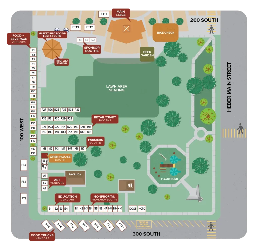
Please join us on June 11th from 5:00-9:00pm at the Market on Main
Our booth will be next to the Heber City booth just north of the pavilion and restrooms.
Once completed, findings can be reviewed individually by property owners by contacting Tony Kohler with Heber City.
Project Summary
Heber City has been working on a community‑focused planning effort to shape the future of the downtown area identified as the Envision Central Heber Plan “C” Street Vision. The study area is bounded by Center Street, 200 South, Main Street, and 100 West. This project will explore opportunities to revitalize underutilized properties, identify potential environmental mitigation and consider reuse options that support a vibrant, walkable, and connected downtown. The project is being conducted with a Brownfields Grant awarded to the Utah Department of Environmental Quality and is funded by the United States EPA.
The project began by presenting the approach, schedule and answering questions with the City Council in their Council Retreat. This was followed by a clarification session with Utah State Department of Environmental Quality (DEQ) / Division of Environmental Response & Remediation (DERR)and Consultant staff. Next, a visual and desktop study of existing conditions—such as land use, buildings, infrastructure, and environmental considerations was completed. This information will:
1) Inform the City and property owners of potential need for future environmental assessment in consideration for development reuse,
2) Better understanding of opportunities and constraints within the study area, and
3) Guide the city and property owners in redevelopment and
4) Support public engagement efforts to inform and gather feedback from the public on redevelopment steps and opportunities.
Community input is a central part of the planning process. Residents, business owners, and stakeholders are invited to share ideas and priorities through public meetings and outreach. Feedback will help inform concepts for land use, housing, businesses, open spaces, and amenities that reflect local values and community goals.
A key focus of the Envision Central Heber Plan is creating a cohesive “C Street Experience”—a welcoming, pedestrian‑oriented connection linking City Hall, Main Street, and the Trailhead Plaza. The plan will also look at ways to improve walkability, accessibility, parking, and connections to nearby destinations. This project will help refine the “C” Street Vision and identify future opportunities for both the City and private property owners.
The project will result in a clear and visually engaging vision plan that includes potential redevelopment concepts, streetscape improvements, and design ideas to guide future investment and grant funding. This plan will serve as a roadmap to support revitalization, economic development, and environmental sustainability in downtown Heber City.
FAQ’s
EPA defines a Brownfield site as “Real property, the expansion, redevelopment, or reuse of which may be complicated by the presence or potential presence of a hazardous substance, pollutant, or contaminant.”
Essentially, it is a property that could have environmental hazards associated with it or is thought to have environmental hazards associated with it, that is potentially preventing the property from being redeveloped. The definition is very broad and can apply to many properties across the country. It is important to note that a property identified as a Brownfield does not mean the property contains hazardous substances. Environmental testing is required to confirm hazardous substances at a property.
By definition of a brownfield property (see above), potential brownfield properties were identified in the study area. However, environmental testing was not performed to confirm or deny potential hazardous substances in this study. Historical information was reviewed that identified past operations in the study area that may pose a risk of hazardous substances (e.g. – former gas stations, former dry cleaners, automotive repair facilities, age of structures, etc.).
Many Brownfield properties get redeveloped into essential community structures. Property owners or potential purchasers of these properties can work with State and EPA agencies to address cleaning up hazardous substances, which provides the opportunity for the property owner or new purchasers to redevelop the property to become valuable community assets. Revitalizing brownfield properties in a community can provide employment opportunities, affordable housing, help stimulate the local economy, and provide a place of community gathering.
“C” Street is envisioned as a year‑round dining and commercial corridor in the heart of downtown Heber City. The project is intended to support existing residents and businesses while creating opportunities to live closer to downtown services and amenities.
Planning for future improvements involves collaboration with property owners, stakeholders, and the public to understand preferences, gather feedback, and identify priorities. This process helps City leaders make informed decisions that support daily activities, strengthen local businesses, and preserve Heber City’s unique character and heritage.
Previous planning efforts, including the Envision Central Heber Plan, established a high‑level vision for a future pedestrian‑oriented corridor. This project represents the next step—moving from big vision idea to informed direction.
Community input is essential to refine that vision and guide future decision making. This planning effort uses proven planning tools and resources to help property owners and residents understand revitalization next steps while considering potential environmental concerns, redevelopment opportunities, and site constraints before future investments are made.
The project is currently in a preliminary concept exploration phase. During this phase, multiple options are developed and shared to encourage discussion, gather feedback, and better understand community preferences.
Presenting options helps compare tradeoffs and recognize that priorities may differ—particularly related to downtown commercial, residential, and entertainment uses. Public input on these options will guide the next steps.
Property owners are invited to participate in public engagement activities where study findings and analysis will be shared. Feedback will help inform the identification of a preferred “C” Street concept and bolster the vision.
The finalized study will outline potential environmental considerations, highlight opportunities and constraints, and identify possible next steps to support revitalization. By better understanding site conditions and redevelopment factors, property owners can make more informed decisions and explore future opportunities that benefit both the community and their long‑term property value.
A recommended concept will be guided by:
- Public feedback from engagement activities
- Alignment with property owner and community priorities
- Support for economic benefits to commercial and residential uses
- Practical considerations such as utilities, parking, access, and circulation
Concepts will illustrate:
- Overall site layout and circulation using different forms and spaces created for people. Buildings and land uses suggestions will be identified to gather preference feedback to better understand public desires.
- Alternative locations and sizes of key features will vary in each concept, with the goal of providing alternative ideas for vision refinement.
- Considerations for shading, circulation, vendor needs, and year‑round use
Please note, this plan is still high-level planning coordination and this phase does not finalize architectural or engineering designs. Future design will be informed by confirming community input and guiding City leadership decisions.
The preferred concept will inform future efforts to implement the vision. The final study will serve as a roadmap, outlining steps needed to support redevelopment, reuse best practices, and long‑term investment. It will also assist in identifying and applying for future funding opportunities.
This study focuses on identifying underutilized properties and understanding potential brownfield conditions to determine whether further evaluation may be needed. If the establishments you visit are relatively successful, then they should only benefit from the plan. Revitalization concepts respond to sites where land value exceeds existing improvement value, based on available parcel information from Wasatch County Tax Information.
No uses shown in the plan are approved for implementation at this time. Concepts are informed by analysis, property owner input, and opportunities for greater community benefit and reinvestment.

